Benevár
(Castrum Bene)
Benevár a mai Magyarország két legmagasabb pontját magában rejtő, az Északi- középhegység részét képező Mátra nevű hegység déli részén, a Somor- és Csatorna-patak által közrefogott Várbércnevű kiemelkedésen fekszik.
A 460-470 méteres magasságban elterülő, ma csupán alapfalaiban álló erősség a Gyöngyös városához tartozó Mátrafüred nevű településtől északra helyezkedik el, s a vidék egyik legrégebbi építményeként tartható számon, mely az utóbbi évtizedekben nem csak a magyar, de közép-európai várkutatás szimbólumává is vált.
Az első tudományos jellegű kutatások Kandra Kabos nevéhez fűződnek, kinek 1890-ben megjelent eredményei több turisztikai célú útikönyv alapjául szolgáltak. A várra, s az egykoron hozzá tartozó, vele azonos nevet viselő településre vonatkozó írott adatok átfogó vizsgálatát Draskóczy István végezte el 1988-ban megjelent munkájában. A közel egy évtizedet felölelő régészeti feltárások eredményeiről maga az ásató, Szabó J. József közölt több előzetes, összefoglalóbb jellegű tanulmányt (1984, 1986, 1990), ám a kutatásai teljes kiértékelésére, monografikus feldolgozására már nem vállalkozott.
Mátraalja, mely már a 11. századtól kezdve az Aba- nemzetség birtok- és szállásterülete volt, a Csobánka-ág tulajdonaként tűnik fel a 13. századi forrásokban. A vár lehetséges építtetőjét Csobánka ispán fia, János személyében kereshetjük, aki 1275-ben testvérével, Péterrel egyenlő arányban felosztja az apjuk által rájuk hagyományozott birtokokat, melynek eredményeképp Bene falu, a későbbi Gyöngyös városa, illetve néhány más kisebb település az ő tulajdonába került. Talán ekkor épülhetett fel maga Bene vára is, birtokainak központjaként.
A várra vonatkozó első adat 1301-ből származik, amikor is János három fia, Dávid, László és Sámuel hivatalos keretek közt felosztják egymás között örökölt javaikat. Az oklevél önmagában is kuriózumnak számít, hiszen olyan részletességgel ír le egy Árpád-kori várat, amely nemcsak hazai, de nemzetközi viszonylatban is ritka. Az ezt követő zavaros évtizedekben a Csobánkák Károly Róbert ellenségét támogatva szembekerültek a királlyal, aki megtorlásul 1327-ben megfosztotta őket birtokaiktól, várukat pedig hűséges hívének, Széchenyi Tamás erdélyi vajdának adományozta, kinek leszármazottjai egészen 1424-ig birtokolták azt. A vár további sorsa ismeretlen, 1497-ben egy oklevél már,mint elhagyott vár említi. Az írott adatok alapján a vár történetében két nagyobb periódust különíthetünk el. Míg 1327-ig a Csobánkák egyetlen, minden bizonnyal reprezentatív funkciókkal bíró, és állandó lakhelyként szolgáló vára volt, addig Széchenyi Tamás idejében csak egy volt azon erősségek közül, melyet a magas rangban lévő család birtokolt.
A következő bekezdésben tekintsünk vissza a már fentiekben említett, 1301-ben íródott oklevélre, annak a várra vonatkozó tartalmára. A leírásból értesülünk egy a vár északi oldalán található palotáról, melyet a három fivér egymás között, egyenlő arányban oszt fel, három kisebb, valamint egy a vár közepén álló nagyobb fatoronyról, egy nagyszobáról, egy házról, egyéb kisebb melléképületekről, valamint a közös használatban maradt kapuról, s kápolnáról. A régészeti kutatás egyik fő célja természetesen az volt, hogy az imént felsorolt épületelemek feltárásra, illetve azonosítása kerüljenek, hiszen páratlan lehetőségnek bizonyult az oklevélben szereplő adatok régészeti valósággal történő összevetése.
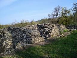
Az ásatások megkezdése előtt a várból csupán jelentős méretű, külső védművei látszottak. Északon és délen egy, a két könnyebben támadható oldalon kettős sánc, illetve árok védte. Régészetileg csupán a belső, átlagosan 3,2 méteres mélységet mutató árka lett megkutatva, a külső esetében,- melynek az alja 7-9 méter mélyen van – a szintvonalas felmérés adott támpontokat.
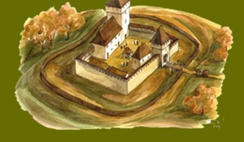
A vár belső magját egy megközelítőleg 40 x 45 méter nagyságú, fallal övezett terület alkotja, mely szabálytalan ötszögformát mutat. Összefüggő falrendszer mutatkozik az északi oldalon, mely helyenként még ma is 2-2,5 méter magasan áll, szélessége 1,70 és 1,90 méter között mozog. A várat keletről határoló falnak csak a belső síkja ismert, déli oldalán is csak csekély nyomai voltak megfigyelhetők. A nyugati övezőfal szerepét az itt feltárt téglalap alaprajzú lakóépület nyugati fala töltötte be. Ebben a vár északnyugati részén elhelyezkedő kőépületben három helyiséget sikerült elkülöníteni. A legészakibb egy 4,50 m x 4,50 m-es belső méretekkel rendelkező építmény, mely védőtoronyként funkcionálhatott. Falvastagsága oldalanként változó, északon 3,20 és 3,70 m között ingadozik, míg délen csupán az 1,76- 1, 93 m-es szélességet éri el, így nem kizárt, hogy maga a torony kétszintesnél is magasabb lehetett. Padlóján elszenesedett gerendamaradványok, s egy felületén megégett faragott kő feküdt utalva a várban pusztító egykori tűzvészre.
A toronyhoz dél felől egy 11 méter hosszúságú, vele egybeépült helyiség csatlakozik, melyet középen falpilléreken nyugvó boltív osztott ketté. Bejárata az északkeleti oldalon nyílott, ahonnan egyenesen a várudvarra lehetett jutni. A terem déli felének helyenként vörösre égett padlóján, akárcsak a toronyban, síkfödémből származó, elszenesedett gerendák, s faragott kövek voltak megfigyelhetők.
Az épület legdélebbi része egy 5,6 x 6 méteres belső terű helyiség, mely földszinti bejárattal nem rendelkezett, így funkciója egyelőre tisztázatlan. Északi falába faragott köveket építettek be, így nem kizárt, hogy utólagos elfalazásról van szó. Az épület egészén vékony égésréteg futott végig, amely a vár pusztulásával hozható összefüggésbe. A várudvar keleti részén farkasveremként értelmezhető, közel 2 méter mély sziklába vájt mélyedés került elő, melyet egy 5,30 m x 4,16 m-es belső terű épület fog közre. Délnyugati fala még ma is 1,50 m magasságig áll, míg északi oldalán csak nem teljes egészében kiromlott. A kaputoronyként interpretált, főként 15. századra datálható leleteket produkáló építmény külső oldalán terrazzo padló nyomaira bukkantak.
A kapuépítménytől délnyugatra egy 8,90 m x 5,40 m belső méretű, kőalapozású, felmenő falaiban azonban faszerkezetű építmény alapjai kerültek napvilágra. Északnyugati sarkában kandalló volt megfigyelhető, melynek belsejét téglákkal, külső ívét faragott kövekkel rakták ki. Ugyanezen épület délkeleti sarkában hasonló sárga agyagos tüzelőfelületet sikerült kibontani, melynek közeléből ugyanolyan faragott kövek bukkantak elő, mint az imént bemutatott kandalló szegélykövei, így nincs kizárva kandallóként való értelmezése sem. Az eddig ismeretlen funkciójú, rendeltetésű épület közvetlen környezetéből 13-14. századra datálható leletanyag, valamint nagy mennyiségű állatcsont került elő.
A várudvar közepén egy 3-3,5 méter átmérőjű, függőleges, felülnézetben kör alakot mutató mélyedés volt megfigyelhető. A kizárólag 15. századi leleteket tartalmazó, közel 3 méter mély bevágást az ásató régész vízgyűjtő ciszternaként határozta meg. A külső sáncároktól délre három gyűrűszerű képződmény mutatkozott, közülük egy került feltárásra. Kiderült, hogy padkás típusú mészégető kemence ez, melyet a benne illetve közvetlen környezetében talált, 14-15. századi leletanyag a legutolsó itteni építkezéshez köt, erről azonban biztosabb ismeretekkel nem rendelkezünk.
Ha kísérletet teszünk az 1301-es oklevélben leírt, s az ásatáson előkerült objektumok azonosítására, valamint azok összevetésére, kérdések tömkelege fog elénk tárulni, melyek megválaszolása korántsem bizonyul egyszerű feladatnak. Az oklevélben „palatium”- ként említett, a testvérek által három részre osztott díszes nagyterem helyét minden kétséget kizárólag az északnyugati épületegyüttes boltívvel elválasztott termének emeleti részére helyezhetjük, melynek reprezentatív mivoltát az innen előkerült nagyszámú faragott kőtöredékek is alátámasztják.
Korántsem ilyen egyszerű a négy fatorony azonosítása, melyek pontos helyét illetően az oklevél nem ad közelebbi támpontot. Sajnos az ásatás során nem kerültek elő faépítményekre utaló nyomok, igaz a vár közepe, illetve déli oldala még ma is szinte teljes egészében feltáratlan. Az eddigi eredmények alapján az egyetlen szóba jöhető objektum, a vár közepén állott nagy fatorony azonosítására az a kőalapozású, fa felmenő szerkezettel bíró épület, mely a kaputorony szomszédságában került elő, s melynek eredeti rendeltetése egyelőre ismeretlen. Ugyanakkor nem elképzelhetetlen egy, a ciszterna fölött emelkedő fatorony lehetősége sem.
Érdekes ugyanakkor, hogy az északnyugati épületegyüttes kőtoronyként interpretált tagja nem szerepel a forrásban. Elképzelhető lenne, hogy az eltérő falvastagság csupán a véletlen műve? Esetleg kőtorony helyett faszerkezetű toronyra, esetleg tornyokra kellene gondolnunk?
Ugyanilyen problematikus az oklevélben megemlített egyéb épületek (camera, domus) helyének meghatározása is, így a közös tulajdonban maradt kápolna lokalizálása sem egyszerű. Nem gondolom, hogy mint önálló épületet kell elképzelnünk, sokkal valószínűbb egy emeleti helyiség vele való azonosítása, ez azonban régészetileg a vár magas fokú pusztultsága miatt lehetetlen.
Minden bizonnyal helyesnek tartható a kaputorony azonosítása is a keleti oldalon, melyet az itt feltárt, farkasveremként interpretált mélyedés egyértelműen meghatároz.
Mindezen tényezők alapján a vár több lehetséges rekonstrukciós lehetősége is felmerült, melyek alapját minden esetben a masszív torony s a hozzá kapcsolódó palota képezte.
Benevár leletanyagának jelentős részét cserépedények alkotják, melyek főként a 13.-14. századra jellemző fehér anyagú, csigavonalas díszű fazekak darabjai. Több vastárgy is felszínre került: patkók, sarkantyúk, kulcsok, csontnyelű kések, s különböző alakú nyílhegyek. Továbbá előkerült egy európai viszonylatban igen ritka, sötétkék színű, arannyal szegélyezett, fehér email festésű arab írással díszített pohár töredéke, melynek jelenléte, idekerülésének körülménye már önmagában rengeteg kérdést vet fel, így jövőbeni vizsgálata mindenféleképpen új eredményekkel gazdagítja majd a hazai kutatást. Maguk a leletek összességében a 13-15. századig datálhatók, amelyek a várra vonatkozó történeti forrásokból vett ismereteinket erősítik.
A fenti ismertetésből kitűnik, hogy az írott, s régészeti adatok összeegyeztetése korántsem egyszerű feladat, hiszen a valóság sok esetben nem tükrözi az oklevélben szereplő adatokat. Ahhoz, hogy a felmerült kérdésekre választ tudjunk adni további ásatásokra lenne szükség, valamint a leletanyag teljes körű feldolgozására, amelynek segítségével lehetőség nyílna a vár életére vonatkozó messzemenőbb következtetések levonására.
Koller Bea, régész

Bene Castle
The Castle of Bene is located on a height called Várbérc between and Somor and Csatorna streams in the Mátra Mountains, North Hungary. The only little remains of the former stronghold are situated 460-470 m above sea, north of Mátrafüred (part of Gyöngyös). The castle is one of the most ancient buildings of the region and has become a symbol for Castle studies not only in Hungary but in the whole Central Europa. The earliest scientific research concerning the castle is connected with Kabos Kandra whose results published in 1890 werw used as a basic for the later tourist descriptions. Almost hundred years lasted until István Draskóczy collected all the written sources about Castle of Bene and the former neighbouring village of the same name. This was published in 1988. The excavations of the site were continuing for a decade, from 1982 until 1992. József J. Szabó of was the leader of the archaeological research and he has partially published his results in 1984, 1986 and 1990. However, the complete evaluation of the material as well as the publication of the latest results or a monograph was never prepared. This duty was transferred to the writer of the present study who is trying to answer the questions raised during the excavations and establish a building history of the castle in her ongoing MA Thesis. The neighbourhood of the castle became a domain of Aba Kindred already since early 11th C, after the Hungarian Conquest. The members of Csobánka branch of the mentioned Kindred are said to be landlords of the region in the 13th C sources. Most likely the founder of the castle was John, count Csobánka’s son. He, together with his brother Péter, in 1275 equally divided their father’s heritage resulted in that the future town Gyöngyös, Bene and several other villages became John’s estate. The castle itself must have been constructed shortly after this event as one of many similer artistocrat seats. The first data concerning the stronghold is known from 1301 when it as a part of family heritage was divided between John’s three sons David, Ladislaus and Samuel. The charter is quite unique because of the very detailed description of a 13th C castle in such an early period. The family joined the opponents of Charles Robert of Anjou during the following internal struggle and consequently the last becoming the King of Hungary dispossessed them of all their domains and granted those to Thomas of Szécsény, voivode of Transylvania.The family of Szécsény held these lands with the castles up to 1424. Nicholas of Szécsény, Thomas’ great-grandson was found guilty of disloyalty to the King, so all his property was acquired and confiscated by Sigismund of Luxemburg. The further fate of the castle is unknown. Most probably the King ordered itt o be pulled down. A charter from 1497 mentions Bene as abandoned and dilapidated. According to the written sources there are two main phases in the building history of the castle. Int the time of prossession of Csobánka family is served as a living place and a residence suitable for lords of the higher rank. In turn, since Thomas of Szécsény’s time, it was just a subsidiary castle used as an administrative and economical centre of the domain lead by a castellan. The already mentioned 1301-year charter is worthy of a worthy of a closer look. Describing the the castle it mentions a palace at the northern side., which was divided equally between the brothers; three smaller towers and one larger wooden tower situated in the centre, a larger chamber, a house and other outbuildings. The chapel and the gatehouse were used collectively by the brothers. Among the main goals of the archaelogical research was to unearth and identify these buildings giving an unique opportunity for comparsion of the written sources with the archaelogical data. Only some derelict earthworks showed the site of the castle by the time of the first season of archaelogical excavation. The core of the stronghold was surrounded by irregular dry moat fortified with additional fosses at the most vulnerable northern and southern sides. The excavations investigated only the innermost ditch which reached 3.2 m depth. The other parts of the earthworks were only surveyed superficially and put to the ground plan. The core of the castle is consisted of a non-regular pentagonal, approx. 40×45 m stone bulding complex. The outer stonewalls survived at the northern side reaching in some places height of 2.5 m and width of 1.7-1.9 m. The eastern and southern outer walls remained only partially. The northern side was closed by the palace building. The excavated walls were slightly heightened during the conservation works. The palace building situated in the north-western corner of the castle includes three chambers. The northernmost with a south-eastern doorway is 4.5×4.5 m large and has thicker walls (3.2-3.7m) than the other parts of the palace (1.7-1.9 m) and thus it can be interpreted as foundation of a tower. The remains of the burnt timbers and also a burnt door-frame stone excavated inside this tower referred to a devastating fire which possibly caused the final destruction of the castle. The palace continued to the south with an adjoining 11 m long chamber split in two by an archway roughly at its lateral axis. The entrance was at the north-eastern side opening directly onto courtyard. Charred beams, collapsed and burnt carved stones found in the southern part of the chamber and fact that the floor in some places had burnt to red also refer to an intense fire. The southernmost part of the palace is a 5.6×6 m large chamber having no traces of ground-floor entrance. Its function is unclear. Some secondarily built in carved stones were walling up could be traced. A thin burnt layer connected with the destruction of the castle ran along the whole building. The destruction layers of the building debris as well as the rubble of the courtyard presented a large amount of different finds dated to 13-15th C. Unfortunately, this was not yet evaluated. A small tower interpreted as a gatehouse was excavated at the north-eastern side of the castle. According to the finds from its remains it can be dated to 15th C. Its uncovered walls somewhere are still 1.5 m high. An almost 2 m deep and 5.3×4.2 m large rock-hole was found within its walls most probably used as trou-de-loup or drawbridge pit. Just slight remains of ground walls of another building were unearthed south-westward of gatehouse. Its inner size is 8.9×5.4 m, foundations were made of stone but basing on architectural features the upper part was timber-framed. Some traces of a former fireplace were identified in the north-western corner of this building. The hearth of the fireplace was of bricks and it was surrounded by a carved stone wall. Most probably another fireplace was also in the south-eastern corner of the same building but only remains of the burned earthen hearth and some random carved stones were found. This building of still unknown function according to the archaeological material from its destruction layers can be dated to 13-14th C. A rock pit 3-3.5 m in diameter and 3 m deep was excavated in the centre of the courtyard. Its fillings contained exclusively 15th C finds. It can be interpreted as a cistern. Three unusual ring-shaped object were unearthed southward of dry moat. Only one of them was completely excavated . It appeared to be a lime kiln which containing finds from 14-15th C can be connected to the last phase of the castle. Trying to connect the data from the charter with that got from the excavations a number of questions rise up answering which is quite difficult. The „palatium” of the charter interpreted as a great hall must have been situated above the long chamber split in two by an archway of the north-western building. This can be confirmed by many carved stones belonged to the representative interior of the hall and found among debris during the cencavations. Even more problematic is the identification of four wooden towers („tribus Turribus ligneis” and „lignee Turris in medio eiusdem castri”) because the charter gives no hints where they could have stayed within the castle. Not too many traces of such constructions were discovered during the research, however, the central and partially the southern parts of the castle were not investigated. According to the present day stage of the research one of the wooden towers may be identified with with the stone-based timber-framed building beside the gatehous. The other possible localisation can be connected with the rock pit in the centre of the castle: the tower might have stood above it. Interesting still that the northern part of the north-western building interpreted as a tower due its thick walls is not even mentioned in the charter. This can be explained in two ways: or it was unintentional or only the ground floor of the tower had such impressive walls and its upper part was timber-framed. Also problematic is the localisation of other chambers described in the charter (camera, domus) and even the former site of the chapel used by all three of the brothers is unknown. It seems that most of these rooms were located somewhere inside the north-western building. The localisation of the gatehouse to the eastern side of the castle seems to be quite sure due to the drawbridge pit. However, the excavations revealed some architectural details referring to that the tower of the gatehouse was built later and originally a simple doorway was used as the castle entrance. This is the only alteration connectable to the later phase of the stronghold which in other way kept its primary appearance up till its final destruction. The pottery is the main group of finds similarly to many other castles. This is composed mainly of spiral.ornamented white ware dated to 13-14th C. Lots of iron objects were found, including horseshoes, spurs, keys, bone handled knives and different arrowheads. The most unique find was a very rare dark blue, golden rimmed glass sherd with enamel painted Arabic script. The way how it got here is very intriguing in itself thus a separate research based on it may have interesting results in the future. Altogether the finds can be dated to 13-15th C only confirming the dating built on the written sources.
Bea Koller, archeologist